This Christmas, one of the most welcome gifts is a cellphone or a Tablet. Not only for adults but also for children who are now tech-savvy.
Ban Toxics, a group that goes by the motto that “The only world worth passing to our children is toxic- free” advises all of us to go slow on new gadgets.
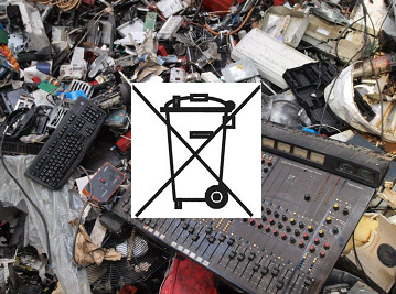
E-Waste. From European Commission website
Toxic materials poison the land, the waters and the air. That is poison we imbibe.
Ban Toxics says “Toxic metals, such as mercury, bio-accumulates in living organisms and can cause neurological and respiratory problems.”
There is no turning back to the time when one can live and work without electronic equipment and gadgets. But there are ways to enjoy the convenience and efficiency of the electronic age while limiting society’s exposure to the toxic metals from e-waste materials. Here are five tips from Ban Toxics:
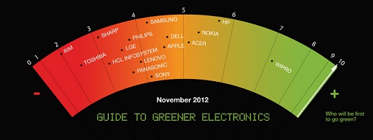
1.Be smart and look for greener electronics. Organisations like Greenpeace have compiled a list evaluating electronic companies’ commitment and progress on reducing their environmental footprint (www.greenpeace.org/international/en/campaigns/toxics/electronics/how-the-companies-line-up/).
You can actually buy electronic goodies with very little toxins in them. Be mindful of your purchases and look for electronics with the RoHS logo (European Union’s Restriction of Hazardous Substances, which requires electronics manufacturers to eliminate toxins in the products they sell such as lead and cadmium). Aside from the RoHS logo, look for products with the Energy Star label, J-Moss (Japan Ministerial Ordinances), and WEEE compliant logos.
2.Think twice before you throw your gadget in the bin. Properly dispose your items through DENR-registered disposal hazardous waste facilities (www.emb.gov.ph/portal/Portals/8/Documents/A4-Treater%20January%202014.pdf).
Globe Telecom acknowledges the importance of proper e-waste disposal and conducts a mobile recycling programme. They accept old phones in many of their participating stores (www.globe.com.ph/globebridgecom/project1phone). Alternatively, ask your electronics manufacturers if they have a take-back policy or trade-in programes.
3. Groups such as the Basel Action Network have established the e-Stewards Initiative an electronics waste recycling standard that hold electronics recyclers in North America to recycle locally and not export their toxic e-waste to developing countries such as the Philippines. Recycling initiatives such as these are gaining momentum. Check around your city if you have reputable recyclers that have passed similar certifications.
4. Bring life to the old by taking your faulty electronics to your local accredited electrician or service centers. The cost of getting them fixed can outweigh the cost of getting a new one. If they’re not faulty, you can still give them a new lease of life by selling them online through sites, such as olx.ph and ayosdito.ph.
5. Re-consider whether you need new gadgets. If your electronics is still within its functional capacity, the latest update might not be worth the added social and environmental cost.
Reduce risk to health by reducing E-waste. That’s the best Christmas gift you can give to yourself, your family and to the community.