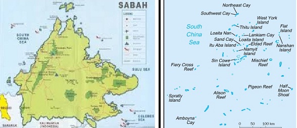
Sabah and Spratlys
The Philippines has offered to downgrade its claim on Sabah in exchange for Malaysia’s support for its case against China before the United Nations.
The quid pro quo was contained in a note verbale the Department of Foreign Affairs handed to a representative of the Malaysian Embassy last week, a week after the visit of Malaysian Defense Minister Dato Seri Hishammuddin Tun Hussein.
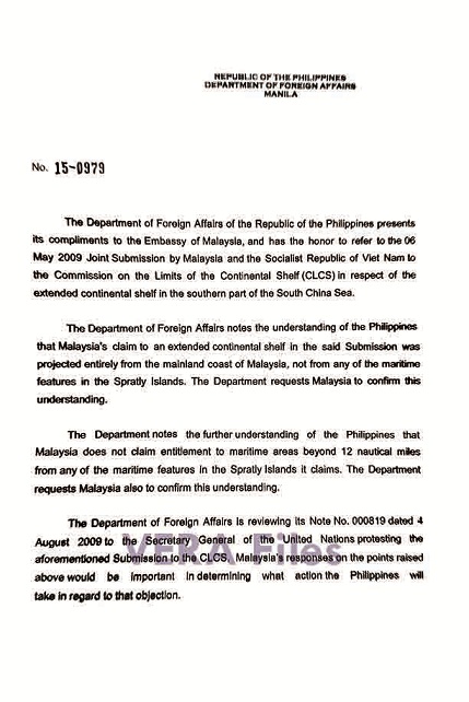
The note verbale, a copy of which was obtained by VERA Files, referred to the May 6, 2009 joint submission by Malaysia and Vietnam to the United Nations Commission on the Limits of the Continental Shelf (CLCS) in which Malaysia claimed an extended continental shelf (350 nautical miles from baseline) that was clearly projected from Sabah.
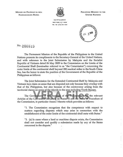
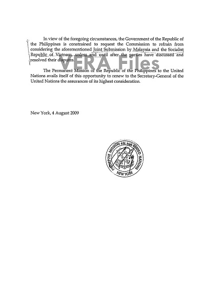
The Philippines, in an Aug. 4, 2009 note to the U.N. Secretary General, protested the joint submission because it effectively declared Sabah to be a Malaysian territory.
The Philippines claims ownership of Sabah, which is at present occupied by Malaysia, based on the title of the Sultan of Sulu who ceded proprietary rights over the 76,115-square-kilometer land to the Philippines in 1962.
In last week’s note verbale, however, the DFA informed the Malaysian government that it is “reviewing” its 2009 protest and its action would depend on Malaysia’s response to Manila’s two requests related to the South China Sea conflicting territorial claims.
DFA comment issued March 30:
The Philippines has excellent relations with Malaysia. In the context of our friendly bilateral relations, our two countries have been for years exchanging ways on how to address the issue of the extended continental shelf (ECS) in the South China Sea.
The Note Verbale that was written about was part of this process. The Note is about the features in the South China Sea and their implications on ECS claims. Sabah is not in any way part of the Note.”
The first request is for Malaysia to “confirm” that its claim of an extended continental shelf is “entirely from the mainland coast of Malaysia, and not from any of the maritime features in the Spratly islands.”
The DFA also requested Malaysia to confirm that it “does not claim entitlement to maritime areas beyond 12 nautical miles from any of the maritime features in the Spratly islands it claims.”
Under the U.N. Convention on the Law of the Sea (UNCLOS), a state is entitled to 12-nautical-mile territorial sea over which it exercises sovereignty.
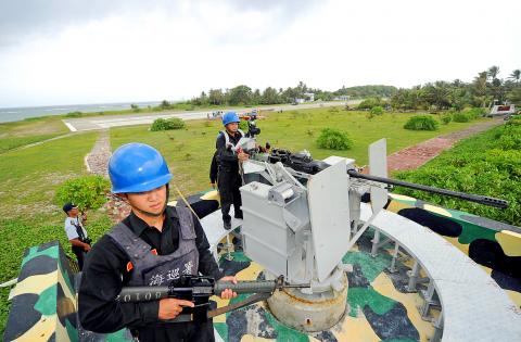
Malaysia, like the Philippines, claims parts of the Spratly islands in the South China Sea which is being claimed almost wholly by China, Vietnam and Taiwan. Brunei is another claimant to some parts of the Spratlys.
There are some parts in the Spratlys where the 200 NM Exclusive Economic Zones of the Philippines and Malaysia overlap.
The DFA didn’t issue any statement when VERA Files sought its comment on the note verbale and its implications.
Former Philippine Permanent Representative to the United Nations Lauro Baja Jr. said the Philippine claim to Sabah will be “prejudiced” if Malaysia accedes to DFA’s request.
“We are in effect withdrawing our objection to Malaysia’s claim of ownership to Sabah,” he said.
A DFA official who requested anonymity, said, however, the Philippine claim to Sabah would remain intact even if Manila withdraws its 2009 objection to Malaysia’s submission to the U.N.
Baja countered, “Even if we are not formally dropping the Sabah claim, it (the withdrawal of the protest) can be used as evidence against our claim.”
A DFA source said officials involved in the case against China before the U.N. Arbitral Court said if Malaysia confirms it doesn’t claim beyond 12 nautical miles from any maritime features in the Spratlys Islands it claims, the Philippine case will be strengthened because one of Manila’s demands for relief from the U.N. court is to declare that certain features, such as rocks, do not generate maritime entitlement beyond 12 nautical miles.
This would clarify that the 12 nautical miles surrounding among others, the Panatag Shoal, also known as Scarborough Shoal or Bajo de Masinloc (Chinese name: Huangyan Island), are part of the Philippines 200-nautical-mile Economic Exclusive Zone.
The Philippines suit, which primarily sought to nullify China’s all-encompassing nine-dash line map invalid, also wants the U.N. court to rule that submerged features within and beyond 200 nautical miles of the Philippines are not part of China’s continental shelf. This would make China’s occupation of these features a violation of UNCLOS.
A diplomatic source said Malaysia may find the Philippine request “too hard to handle” because it has adopted the policy of “playing it safe”—expressing concern on China aggressiveness in the disputed waters while maintaining good relations with the economic superpower.
“A maritime entitlement of only 12 nautical miles for their reefs, as the essence of the Philippines request, will not be in the interest of Malaysia. Besides, Malaysia will not risk its close economic ties with China, its biggest trading partner,” the source said.
The source said China also protested the 2009 Malaysia-Vietnam submission to the U.N. So even if the Philippines withdrew its objection, the Chinese protest would stand, the source said.
The CLCS would not proceed on the Philippines’ withdrawal of its protest unless and until the Chinese 9-dash line claim is rendered invalid.
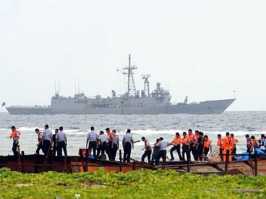
Also last week, the Philippines submitted a supplemental argument in answer to China’s position paper on the Spratlys territorial claim. The U.N. is expected to hand down its decision in 2016.
Meanwhile, the Philippines has denounced the massive reclamation of China on its occupied reefs.
Baja said the Philippine position on Sabah is much stronger than its Spratly islands claim. Economically, the timber and mineral-rich Sabah is much more valuable than Spratlys, he added.
There are more than 600,000 Filipinos in Sabah, most of them considered by Malaysia as illegal residents and are often subject to harassment.
Sabah (North Borneo) originally belonged to the Sultan of Brunei, who gave it to Sultan of Sulu Salah ud-Din Karamat Bakhtiar in 1658 as a reward for helping quell a rebellion. In 1878, Sulu Sultan Jamalul Alam Kiram leased North Borneo to the Hong Kong-based British North Borneo Co. of Baron Gustavos von Overbeck and Alfred Dent for 5,000 Malaysian dollars a year.
In 1946, Overbeck and Dent, without permission from the Sultan, transferred the territory to the British government when the company ceased operations.
On Sept. 11, 1962, Sultan of Sulu Mohammad Esmail Kiram ceded to the Philippine government full sovereignty, title and dominion over the territory. President Diosdado Macapagal filed the Philippines’ claim over Sabah with the United Nations.
In 1963, the British government, again without permission from the Sultan of Sulu, transferred Sabah to the newly formed Federation of Malaysia.
Malaysia is currently the broker in the peace talks between the Philippine government and the Muslim rebel group, the Moro Islamic Liberation Front (MILF) for the creation of a Bangsamoro, an autonomous political entity in the southern part of the Philippines.—with additional reports by Ellen Tordesillas
(VERA Files is put out by veteran journalists taking a deeper look at current issues. Vera is Latin for “true.”)