Long before China built lighthouses in reefs they are occupying in the disputed Spratlys, the Philippine government under President Fidel Ramos had planned to build lighthouses in Reed Bank and two other reefs but inter-government wrangling over money stalled the project until it was overtaken by events.
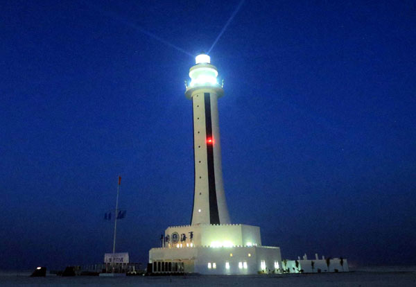
Last Tuesday, China announced its plan to construct lighthouses in two reefs in Spratlys which it calls Nansha Islands.
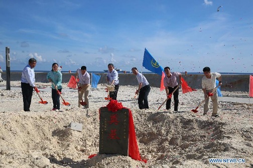
Groundbreaking ceremony for the construcion of Lighthouses in Huayang Reef and Chigua Reef. Xinhua photo.
A news item in Xinhua, a Chinese news agency, China to Build Large Lighthouses in South China Sea said, “China’s Ministry of Transport (MOT) on Tuesday hosted a groundbreaking ceremony for the construction of two lighthouses on Huayang Reef and Chigua Reef of China’s Nansha Islands.
“In order to enhance the civil aids to navigation capacity in the waters of Nansha Islands, the MOT plans to construct two multi-functional lighthouses, which will provide efficient navigation service to the passing vessels and “immensely improve the navigation safety” in the South China Sea, according to a statement from the MOT.
“Integrated with elements of traditional Chinese culture, the two 50-meter-high lighthouses, with lanterns of 4.5 meters in diameter, are designed to have a light range of 22 nautical miles.
“The South China Sea is an important international maritime transport route as well as a major fishing ground. A large number of fishing vessels operate in this area all year round, which has led to many maritime traffic accidents.
“Lighthouses are vital public facilities for navigation safety, and are usually constructed at key ports and critical positions of waterways to provide navigation service for vessels or indicate dangerous areas through refraction from the lens on the top.”
Pictures of the groundbreaking ceremony on Huayang Reef (Philippines name: Cuarteron) were posted in Xinhua’s website.
The lighthouses are additional facilities in the reefs where China has been doing massive reclamation and construction of what looks like military installations. Chigua Reef’s Philippine name is Mabini Reef. It is also known as Johnson South Reef.
South China Sea observers say the lighthouses could be another way of China’s circumventing the United Nations Commission on the Law of the Sea Provision (UNCLOS) that baselines could be drawn from low tide elevations or LTE (naturally formed area of land which is surrounded by and above water at low tide but submerged at high tide) if there are lighthouses or similar installations built on them.
Former Ambassdor Alberto Encomienda, now the executive director of Balik Balangay, a non-stock, non-profit conservation organization focusing on the marine environment and resources, said that UNCLOS provision applies only to naturally- formed features. What Cuarteron and Mabini Reefs now are artificial islands.
Lawyer Harry Roque also said the UNCLOS provision on lighthouses on LTEs applies only to archipelagic states (State or country that comprises a series of islands that form an archipelago.) which China is not.
The Philippines is an archipelagic state. Documents obtained by Vera Files showed that as early as 1994, Ramos ordered various agencies to work together on projects to redefine the country’s archipelagic baseline.
Documents obtained by Vera Files showed that as early as 1994, Ramos ordered various agencies to work together on projects to redefine the country’s archipelagic baseline.
In mid-1994, then Administrator Jose Solis of the National Mapping and Resource Information Authority) sought financial assistance from then Energy Secretary Delfin Lazaro for the building of lighthouses on three islets in the KIG: Nares Reef, Recto Bank or Marie Louise Reef, and Sea Horse Bank.
This was about the time that the Chinese were starting to occupy Mischief Reef in the KIG, which is only 135 nautical miles away from the Philippine baseline. The Philippine government authorities found out about it in February 1995.
Lazaro supported the lighthouses project and sought Ramos’ approval to draw funds from the DOE’s Special Account.
In a memo to Ramos, Lazaro cited possible international complications and risks of the lighthouse project: “While this project will be beneficial to the Philippines in terms of expanding available area not only for petroleum exploration but for other natural resources as well and that the lighthouses will also be important navigational aids, we wish to point out that actual construction of the lighthouse could provoke international protests from other countries (such as China and Vietnam) including possible physical stoppage of the work by their navies.”
Lazaro’s request for a go-signal got stalled in Malacanang. His successor, Francisco Viray, pursued the lighthouse project. In a memo to Ramos dated Dec. 12, 1994, Viray said: “Once established, these lighthouses will serve as legal basis in determining the new baseline. Other countries are doing the same things to fortify their territorial claims.”
Viray said the presence of lighthouses would reinforce the country’s claim over the Reed Bank. A lighthouse would have qualified Reed Bank, which is within the 200-mile exclusive economic zone, to be part of the archipelagic baseline.
“The inclusion of the Reed Bank within the baselines will effectively increase our archipelagic waters within the baselines by 11,042 square nautical miles or 7,750,000 hectares. This will mean that we can fully exercise sovereignty over this resource-rich area. It must be noted that the inclusion of this area within the EEZ only does not assure full exploration/exploitation rights. Under UNCLOS, other countries can come in as long as they pay royalties,” Viray said.
Documents showed that on Feb. 15, 1995, Ramos finally approved the release of P178-million for the mapping, survey, and construction of lighthouses in the KIG. He instructed the DOE to supply the funds, and the NAMRIA to supervise the design and construction of the lighthouse as well as the coordinates of the benchmarks identifying the territorial limits based on the 200-nautical mile EEZ. Formal public bidding was waived “in view of the urgency and confidentiality of the project.”
But soon after the funding was approved, Ramos himself revoked the authority of NAMRIA, which is under the Department of Environment and Natural Resources to oversee the project and transferred it to the Philippine Navy upon the recommendation of Defense Secretary Renato de Villa.
This led Solis to complain in a June 6, 1995 memo to then Environment Secretary Angel G. Alcala: “The NAMRIA has been religiously working for the immediate implementation of the KIG project. I would like to inform the Executive Secretary that when there were still no available funds for the project, it was the NAMRIA which did all the work to convince the funding agency to support the project. However, when the funding was approved and the authority was given to the NAMRIA, the Cabinet made a decision to transfer the project to the Philippine Navy.”
The KIG lighthouses never got built—and the Philippines has lost its chance to build them.
By the time Solis wrote Alcala, the Chinese garrison was already discovered in Mischief Reef (February 1995). Philippine protest over Chinese occupation of Mischief Reef led to an ASEAN Declaration on the Code of Conduct of Parties in the South China Sea which enjoins “ Parties undertake to exercise self-restraint in the conduct of activities that would complicate or escalate disputes and affect peace and stability including, among others, refraining from action of inhabiting on the presently uninhabited islands, reefs, shoals, cays, and other features and to handle their differences in a constructive manner.”
The Philippines is protesting the building by China of lighthouses in the disputed reefs as a violation of the ASEAN DOC. That’s all that we can do.