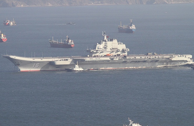
Liaoning, China’s first aircraft carrier, back from a test mission in Hainan.
Alarm bells rang again with the announcement last week by China that Hainan, its southernmost province, was implementing a Fishery Law that requires foreign fishing boats to get its approval when venturing into the South China Sea starting Jan. 1, 2014.
Hainan, with an area of 32,900 square kilometers, is China’s smallest province. Yet the Fishery Law, which China claims to have been adopted in 1993 and amended in 2008, puts under Hainan’s authority two million square kilometers of the vast South China Sea (estimate size is 3.5 million square kilometers), parts of it are also being claimed by the Philippines, Vietnam, Brunei, Malaysia and Taiwan.
The Philippines’ Department of Foreign Affairs said “This new law reinforces China’s expansive claim under the 9-dash line (map)” which it has questioned before the United Nations Arbitral Tribunal.
“It is a gross violation of international law. This development escalates tensions, unnecessarily complicates the situation in the South China Sea, and threatens the peace and stability of the region,” the DFA said.
Vietnam said the Fisheries law is “illegal and invalid” and seriously violates its sovereignty. It demanded that China abolish the measure.
Taiwan, which claims all that China is claiming, called on countries “bordering the islands “to refrain from adopting unilateral measures that might upset the peace and stability of the region and the South China Sea.”
The United States termed China’s latest move related to the South China Sea issue “a provocative and potentially dangerous act.”
The implementation of the Fisheries Law comes after the completion of China’s first aircraft carrier, Liaoning, of its training mission which began November last year off the coast of Hainan.
It also signals the growing confidence of China of its maritime capability. A White Paper on ““The Diversified Employment of China’s Armed Forces” available in Xinhua news agency website speaks of “China’s development of an aircraft carrier has a profound impact on building a strong PLAN and safeguarding maritime security.”
The paper gives a glimpse of the strength of China’s Navy which is responsible for “maintaining China’s sovereignty over its territorial seas along with its maritime rights and interests.”
The White Paper says,“ The PLAN is composed of the submarine, surface vessel, naval aviation, marine corps and coastal defense arms. Currently, the PLAN has a total strength of 235,000 officers and men, and commands three fleets, namely, the Beihai Fleet, the Donghai Fleet and the Nanhai Fleet. Each fleet has fleet aviation headquarters, support bases, flotillas and maritime garrison commands, as well as aviation divisions and marine brigades.”
The province of Hainan as implementing authority of the Fisheries Law brings the challenge closer to the Philippines because in June 2012, China established Sansha City on Yongxing Island in Hainan which covered islands in the Paracels, Macclesfield Bank and Spratlys.
Vietnam says the Paracels is theirs (The group of islands was a scene of a fierce battle between Vietnam and China 40 years ago. A Vietnamese warship sank together with its captain and crew. It is now controlled by the Chinese) while the Philippine territory includes Macclesfield Bank, one of the largest underwater atolls in the world covering an area of 6,500 square kilometers, and some parts of Spratly Islands.
Macclesfield Bank is part of Zhongsha Qundao , a group of five rocks that also includes the Scarborough Shoal, Truro Shoal, Saint Esprit Shoal, and Dreyer Shoal.
Scarborough Shoal (also known as Bajo de Masinloc and Panatag Shoal in the Philippines and called Huangyan Island by the Chinese) is a contentious issue between the Philippines and China. Until recently three Chinese guarded the area, only 124 nautical miles from Zambales and 550 nautical miles from Hainan Island, after a standoff in April 2012 following the arrest of Chinese fishermen in the area by a Philippine Navy warship.
A paper titled “Geopolitics of Scarborough Shoal” written by Francois-Xavier Bonnet of the Bangkok-based Research Institute on Contemporary Southeast Asia (IRASEC) points out the important connection of Macclesfield Bank with Scarborough Shoal and the controversial U-shaped 9-dash line map of China which is the basis of their claim of almost 90 present of the whole South China Sea.
Bonnet explained, “The Zhongsha Qundao is composed of Macclesfield Bank, Truro Shoal, Saint Esprit Shoal, Dreyer Shoal and Scarborough Shoal. All these banks and shoals, except for Scarborough Shoal, are under several meters of water even during low tide. Chinese policymakers know too well that without Huangyan island, the chance of their ownership over Changsha Qundao recognized is nil.”
Bonnet said, “The stakes are high. If China loses Huangyan/Scarborough, it will lose Zhongsha Qundao, which could be divided by the EEZs of the neighboring countries or placed under the regime of the high seas. By consequence, China’s entire claim to the South China Sea supported by the U-shape line would be moot and academic.”
In the wake of China’s announcement of Hainan’s implementation of its Fisheries Law, the mayor of Kalayaan town in Spratlys, Eugenio Bitoon, urged Filipino fishermen to ignore it and continue with their usual livelihood.
Bitoon’s reading is that China is just flexing its muscles “in Hainan, Paracels and Macclesfield, which (they claim) are within their EEZ (Exclusive Economic Zone).
Bitoon said it would not be easy for Chinese to arrest non-Chinese fishermen in the disputed area. “If China wants to secure that area, they will need to contain first the Vietnamese in Pugad Island where there is a sheltered port 720 kilometers away from Hainan.”
This is not the time to be complacent.