Binay warned on joint development with China in Spratlys

Vice President Jejomar Binay

Vice President Jejomar Binay

While in Jakarta last week representing President Aquino in the 60th anniversary of the Asia-Africa Conference, Vice President Jejomar Binay articulated what could be a foreign policy shift for the country if he succeeds in his ambition to become president.

“China has all the capital and we have the property so why don’t we try and develop that property as a joint venture?”he said.

Senior Associate Justice Antonio T. Carpio

Senior Associate Justice Antonio T. Carpio

This is not actually new. Binay disclosed this in an interview with Manila Times’ Efren Danao last year.
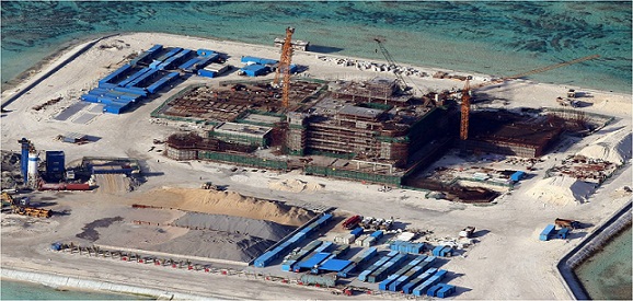
Amid concerns expressed by President Aquino and Foreign Secretary Albert del Rosario over massive reclamations being done by China around their occupied reefs in the disputed Spratlys in South China Sea, Binay further said: “Personally, my feeling is we will continue to insist (on) our sovereignty over those properties but at the same time we hope we can create a situation where we can improve bilateral relations with China.”

Senior Associate Justice Antonio Carpio, who has been conducting a series of lectures on the South China Sea dispute, said in his lecture last April 27 with judges and justices that joint development of the Spratlys with China is not possible without violating the Constitution.

Carpio said, “China’s offer of joint development in the Spratlys has one pre-condition – that the other state concedes to China indisputable sovereignty over the Spratlys. No claimant state has accepted, or will ever accept, China’s offer because acceptance means the accepting state must immediately vacate any island it occupies in the Spratlys since that is the consequence of admitting China’s sovereignty over the Spratlys.”

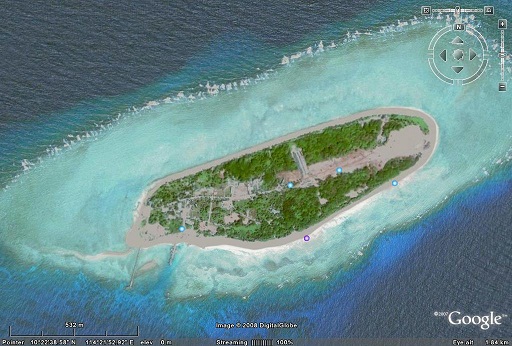
Carpio pointed out that the Kalayaan Island Group (KIG) is part of Philippine national territory as defined in the Philippine Baselines Law (RA No. 3046, as amended by RA No. 5446 and RA No. 9522) and in Article 1 of the 1987 Philippine Constitution on the National Territory.

“Any President who concedes sovereignty over the KIG to China culpably violates the Constitution and commits an impeachable act,” he said.

Carpio also underscored Section 2, Article XII of the 1987 Constitution that mandates the “State shall protect the nation’s marine wealth in its xxx exclusive economic zone, and reserve its use and enjoyment exclusively to Filipino citizens.”

“Conceding to China sovereignty over the Spratlys, whose surrounding waters facing Palawan form part of the Philippines’ EEZ, or even just allowing China to use and enjoy the Philippines’ marine wealth in these waters, violates Section 2, Article XII of the Constitution. Any President who violates this constitutional provision commits an impeachable act,” he said.

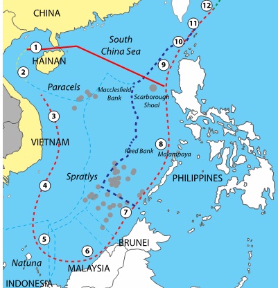
This idea of setting aside the issue of sovereignty for a joint development by claimant countries in the disputed waters of South China Sea was tried in 2004 by the administration of Gloria Arroyo.

The Philippines, China and Vietnam undertook the Joint Marine Seismic Undertaking (JMSU) over a large portion of the Spratlys. Findings in that “seismic undertaking” would be used in the next phase of the cooperation which was joint development.

Even in the JMSU, they had to refrain from using the word “exploration” which foreigners are banned from undertaking in Philippine territory.

SECTION 2, Article XII of the Constitution cited by Carpio also states that, “The exploration, development, and utilization of natural resources shall be under the full control and supervision of the State. The State may directly undertake such activities, or it may enter into co-production, joint venture, or production-sharing agreements with Filipino citizens, or corporations or associations at least sixty per centum of whose capital is owned by such citizens.”

Another problem with the JMSU was, the area explored was all within the 200 nautical miles Exclusive Economic Zone of the Philippines. No EEZ of China and Vietnam was explored. It even covered Philippine territory that are undisputed.

Results of that exploration masked as “seismic undertaking” have not been made public but sources said data on the disputed Reed Bank provided by the Chinese to the Philippines was vague.

In 2008, Bayan Muna partylist questioned the JMSU’s legality before the Supreme Court, and the case remains unresolved.

At least, this early, Binay or anybody who wins in the 2016 elections is forewarned.

No Asean-China COC until China completes Spratlys military bases

Senior Associate Justice Antonio T. Carpio

Senior Associate Justice Antonio T. Carpio

The standard press statement of Malacañang and foreign affairs officials prior to the President’s attendance in the annual summit of the Association of Southeast Asian Nations is for the Philippines to push for the adoption of the Code of Conduct in the South China Sea.

President Aquino did that a week before he took off for Malaysia for the 26th Asean summit. He said, “It’s imperative to push for the formulation of the Code of Conduct” especially now that “even the DOC seems to have been violated.”

The violations of the 2002 Declaration of the Code of Conduct in the South China Sea that Aquino was referring to are the massive reclamations and construction of military facilities in the seven reefs that China occupies in the disputed waters of the South China Sea.

Senior Associate Justice Antonio T. Carpio said last Thursday,during the open forum in his latest lecture on the South China Sea dispute, not to expect the finalization of the Code of Conduct soon, not until China has completed its plan in the South China Sea.

The objective of the COC is to create a rules-based framework for managing and regulating conduct of parties in the South China Sea.

What is in place now is the Declaration of the Code of Conduct in the South China signed by Asean States and China in 2002 to promote a peaceful, friendly and harmonious environment in the SCS where four of the ASEAN countries – Brunei, Malaysia, Philippines and Vietnam – have overlapping territorial claims with China, which claims ownership of almost the whole of the SCS. Taiwan has the same claim as China.

As the name suggests, the DOC is just a declaration and not legally binding.

ASEAN and China have both agreed on the need for a more legally binding legal instrument. The ASEAN-China working group on the COC has met three times but the pace has been very slow.

Asean -China

Asean -China

Foreign Affairs Assistant Secretary for ASEAN Affairs said, “At this point in time, I think the level of discussion of that joint working group is to identify the elements that can easily be achieved or agreed upon, or what they call the ‘low-hanging fruits.’ An example would be the opening of a hotline and activities on search and rescue operation.”

An Asean draft of the COC provides that the signatories “undertake to exercise self-restraint and not to complicate or escalate disputes and affect peace and stability in the South China Sea.”

It is a takeoff from a provision in the DOC which states that “The Parties undertake to exercise self-restraint in the conduct of activities that would complicate or escalate disputes and affect peace and stability including, among others, refraining from action of inhabiting on the presently uninhabited islands, reefs, shoals, cays, and other features and to handle their differences in a constructive manner.”

This is what the President has said as having been violated by China’s creations of islands out of the reefs they are occupying where they are building airstrips and military structures.

Foreign Secretary Albert del Rosario said in his intervention at last Sunday’s Asean Foreign Ministers Meeting scored China saying that “the massive reclamation was clearly intended to change the regional status quo, to advance our northern neighbor’s unreasonable, expansive and illegal so-called Nine-Dash Line claim, to undermine the rule of law and to render the DOC and the COC irrelevant.”

Gaven Reef

Gaven Reef


Analysts believe that China would only consider signing the COC after it has completed its plan of building military installations in the South China Sea that would break the First Island Chain (first major archipelagos off the East Asian continental mainland, including the Japanese archipelago, Ryukyu Islands, China’s Taiwan and the northern Philippines) that were meant to block China’s direct access to the Pacific Ocean.

Carpio said the dispute mechanism in the COC should adopt dispute settlement under the United Nations Commission on the Law of the Sea (UNCLOS).

The Asean draft COC includes a provision to “Establish a mechanism for settling disputes relating to the interpretation and application of the COC guided by the following principles:

• Ensure that any breach of the provisions of the COC will be settled by peaceful means
• Utilize the dispute settlement mechanism under the relevant provisions of the Treaty of Amity and Cooperation in the Southeast Asia.
• If cannot be resolved through procedure within ASEAN framework, parties may resort to dispute settlement mechanism provided under international law including UNCLOS.

Justice Carpio explains Itu Aba issue in the PH suit vs China

Itu Aba, also known as Taiping or Ligaw

Itu Aba, also known as Taiping or Ligaw

Last year, Itu Aba (also known as Taiping or Ligaw), the biggest feature in the Spratly group of islands being disputed by the Philippines, China, Vietnam, Malaysia, Brunei and Taiwan, figured in a controversy involving the appointment of the Solicitor General Francis Jardeleza to the Supreme Court.

Supreme Court Justice Lourdes Sereno opposed the appointment of Jardeleza to the High Court accusing him of treason when he omitted Itu Aba in the Memorial or memorandum filed before the United Nations Arbitral Tribunal in connection with the case filed by the Philippine questioning the legality of China’s nine-dashed line map which overreaches into the territory of the Philippines, Vietnam, Malaysia, Indonesia and Brunei.

Itu Aba is occupied by Taiwan, once part of China but now considers itself a sovereign state as Republic of China. The Philippines adopts a One-China policy which considers Taiwan a province of China.

Jardeleza was of the view that including Itu Aba in the Memorial would weaken the Philippine case because the island has a water source and can sustain human habitation and therefore entitled to maritime regimes. That would be outside the jurisdiction of the Arbitral Tribunal.

As a compromise by Jardeleza and the American lawyers handling the Philippine U.N. case, Itu Aba was included in the Memorial but it was not raised as a legal issue.

Senior Associate Justice Antonio T. Carpio

Senior Associate Justice Antonio T. Carpio

The High Court later cleared Jardeleza of the allegation of treason or disloyalty saying it was
“a legal strategy.”

Last Jan. 29, in a lecture at the Ateneo de Manila, Senior Associate Justice Antonio Carpio touched on Itu Aba.

He said the Philippines has a strong position in asserting ownership of Itu Aba: “Palawan has an area of 1,464,900 hectares, and a 650 KM coast facing the West Philippine Sea, while Itu Aba has an area of 46 hectares and a 1.4 KM coast. The relevant coast for Palawan is about 495 KM, while the relevant coast for Itu Aba is about 1 KM, or a ratio of 1:495 in favor of Palawan.

“The critical criterion is the length of the opposing coastlines in the overlapping maritime zones. Palawan is uniquely endowed by nature with an unusually long coastline – a total of more than 650 kilometers facing the West Philippines Sea. The combined coastline of all the Spratly Islands is minuscule compared to Palawan’s coastline.

“International law, international jurisprudence and nature itself have all combined to give the Philippines an impregnable position in this maritime dispute.”

If the U.N. Tribunal favors the Philippine government’s assertion that Itu Aba is not capable of human habitation or economic life of its own, Carpio said the tribunal will then declare that Palawan has a full 200 nautical mile Economic Exclusive Zone facing the West Philippine Sea.

“This means that all submerged features within this EEZ, like the Reed Bank and Malampaya, are subject to exclusive economic exploitation by the Philippines in terms of fisheries, oil and gas, and mineral resources,” he said.

Furthermore, he said, “If the Philippines has a full 200 NM EEZ in Palawan facing the West Philippine Sea, only the Philippines can create artificial islands on submerged areas or erect structures on LTEs (Low Tide Elevation) within its 200 NM EEZ. Artificial structures or reclamations made by other countries, namely by China and Vietnam, are illegal.”

Taiwan's Coast Guard officers stand on duty on Itu Aba (Taiping island). Sept 2011 photo. Taipei Times.

Taiwan’s Coast Guard officers stand on duty on Itu Aba (Taiping island). Sept 2011 photo. Taipei Times.

On the other hand, if the tribunal rules that Itu Aba is capable of human habitation or economic life of its own, Carpio said the case as far as Itu Aba and Palawan are concerned becomes an issue of overlapping EEZs, outside of the tribunal’s jurisdiction in view of China’s reservation excluding boundary delimitation issues from compulsory arbitration.

“In such a case, the tribunal will then refuse to proceed further except to declare that Itu Aba generates its own EEZ and that there is a boundary delimitation issue on overlapping EEZs between Palawan and Itu Aba. The tribunal has no jurisdiction over such boundary delimitation issue because China has opted out of compulsory jurisdiction over boundary delimitation issues, “he said.

What then would be the recourse of the Philippines?

Carpio said, “The recourse of the Philippines is to file a compulsory conciliation case against China to determine the maritime boundary between Itu Aba and Palawan in view of the overlapping EEZs. Compulsory conciliation is the specific remedy granted by UNCLOS against a member state that has opted out of compulsory arbitration on maritime boundary delimitation. While the decision of the compulsory conciliation commission is not binding, it has strong persuasive effect because it is a statement of what the international law is with respect to the particular dispute.”

How will the compulsory conciliation commission resolve the overlap issue?

Taiwan builds a 1,150- meter wharf in Itu Aba. From Flickr

Taiwan builds a 1,150- meter wharf in Itu Aba. From Flickr

Carpio said, “The distance between Palawan and Itu Aba is 225 NM. Palawan has a 495 KM coastline facing Itu Aba while Itu Aba has only a 1 KM coastline facing Palawan. These opposing coastlines, when projected to seaward, create the overlapping zones.

“The ratio of the length of the relevant coasts is 1:495 in favor of Palawan, showing not only a substantial disparity, but an overwhelming disparity. “

Carpio further explained: “Applying the UNCLOS ‘equitable solution’ principle (no disproportionate allocation of the relevant maritime area between islands with unequal coastlines), Palawan will be allocated a full 200 NM EEZ facing Itu Aba, and Itu Aba will be given the balance of 25 NM as follows: 13 NM EEZ and 12 NM territorial sea facing Palawan. Itu Aba will also have an EEZ facing seaward up to where Vietnam’s EEZ ends.

“Since Palawan can also claim an ECS (Extended Continental Shelf) beyond its 200-NM EEZ, there is an overlap between Palawan’s ECS and Itu Aba’s EEZ. This overlap, called the ‘grey area,’ will be delimited by the compulsory conciliation commission also in accordance with the “equitable solution” principle applied in the delimitation of the overlapping EEZs. Itu Aba will be entitled only to the living resources in its 13-NM EEZ facing Palawan. The non-living resources in the seabed and subsoil within Itu Aba’s 13-NM EEZ facing Palawan will belong to Palawan’s ECS

“Itu Aba will have an EEZ seaward to the South China Sea up to where Vietnam’s EEZ ends. However, the non-living resources in the seabed and subsoil, up to 70 NM (median line between outer limits of Vietnam’s and the Philippines’ EEZs) measured from the outer limit of Palawan’s EEZ, excluding the territorial sea of Itu Aba, will form part of Palawan’s ECS.

“In short, the Philippines is entitled to the oil, gas, minerals and sedentary species in the grey area seaward of Itu Aba – the overlap between Itu Aba’s EEZ and Palawan’s ECS beyond the 200 NM EEZ of Palawan.

“This is the ‘condominium’” solution applied to the ‘grey area.’”

Justice Carpio: China’s 9-dashed line- grand theft of Global Commons

China’s 9-dashed line map, which was recently expanded to 10 dashes, goes against the “concept of global commons” which was the foundation of the 1982 United Nations Convention of the Law of the Sea, Senior Associate Justice Antonio Carpio said in a speech delivered on the 75th Anniversary of the College of Law of the University of San Agustin in Iloilo City last Aug. 30.

Thus,Carpio said, China fisheries laws particularly giving Hainan, China southernmost province, exclusive jurisdiction over the waters in the South China Sea as well as on the fishery resources of Macclesfield Bank is “a grand theft of the global commons in the South China Sea.”

Hainan claims to administer all the waters enclosed by the dashes from 1 to the heavy red line intersecting the dashes between 8 and 9.  The enclosed waters comprise two million square kilometers. China claims a total of three million square kilometers of maritime space, and all the resources found there, out of the 3.5 million square kilometers of maritime space in the South China Sea.

Hainan claims to administer all the waters enclosed by the dashes from 1 to the heavy red line intersecting the dashes between 8 and 9. The enclosed waters comprise two million square kilometers. China claims a total of three million square kilometers of maritime space, and all the resources found there, out of the 3.5 million square kilometers of maritime space in the South China Sea.


Carpio traced the origin of the concept of the global commons way back in the 6th century when The Institutes of Justinian of the Roman Emperor Justinian, declared that the sea is “common to mankind” and its use is subject only to “the law of nations.”

Carpio said the Dutchman Hugo Grotius wrote his famous Mare Liberum or the Free Sea in 1609 that “No nation could claim ownership of the oceans and seas because they belonged to all mankind.”

The naval powers at that time – Spain, Portugal and England – held the opposite view, claiming ownership of the oceans and seas by discovery, he further related.

An opposite view was forwarded by the Englishman John Selden. But Carpio said, “Grotius’ idea eventually won and became the foundation of the law of the sea” earning for the Dutchman the stature as “ Father of international law.”

“Thus, under international law since the turn of the 19th century until today, the waters beyond a coastal State’s territorial sea could never be subject to sovereignty by the coastal State. Before UNCLOS, the territorial sea was a belt of 3-NMs of waters from the coast, and beyond this 3-NM territorial sea was the high seas, belonging to all mankind as part of the global commons. Under international law, before and after UNCLOS, no State could appropriate the high seas as its own exclusive waters. Before and after UNCLOS, the high seas were part of the global commons,” Carpio said.

Here comes China’s 1986 Fisheries Law which was amended in 2011 that requires foreign fishing vessels to secure permission from Chinese authorities “before entering the territorial waters of the People’s Republic of China to carry on fishery production or investigation of fishery resources.”

Carpio sounded the alarm:” The problem arises when China’s Fisheries Law is applied to the high seas, and to the EEZs of other coastal States, that China claims fall within its 9-dashed lines in the South China Sea. China’s 12th Five-Year Plan for National Oceanic Development states that the sea area under China’s jurisdiction comprises three million square kilometers.The 12th Five-Year Plan of the Hainan Maritime Safety Administration states that the sea area under Hainan’s jurisdiction comprises two million square kilometers. The South China Sea has a sea area of three million five hundred thousand square kilometers. In the 1988 decision of China’s National People’s Congress creating the province of Hainan, Hainan’s territory expressly includes Zhongsa Island or what is internationally known as Macclesfield Bank. “

Carpio stressed the importance Macclesfield Bank:

“Macclesfield Bank is one of the largest atolls in the world, with a water surface area of 6,448 square kilometers, about ten times the land area of Metro Manila. Macclesfield Bank lies just outside the Philippines’ EEZ facing the South China Sea in Luzon Island. Macclesfield Bank is named after the HMS Macclesfield, a British warship that ran aground in the area in 1804.

“Macclesfield Bank is not an island but a fully submerged atoll whose highest peak is some 9 meters below sea level. China calls Macclesfield Bank the Zhongsa Island, which is glaringly misleading because the entire area is fully submerged even at high tide. Under UNCLOS, a geologic feature is an island only if it is above water at high tide. Macclesfield Bank does not qualify as an island under this UNCLOS definition. An island is subject to a claim of territorial sovereignty but not a fully submerged atoll beyond the territorial sea like Macclesfield Bank. As a fully submerged atoll beyond China’s territorial sea, Macclesfield Bank is not subject to any claim of territorial sovereignty by China. And since Macclesfield Bank is beyond China’s EEZ, China cannot also claim any sovereign right to exploit exclusively the fishery resources in Macclesfield Bank.
“Under UNCLOS, Macclesfield Bank is part of the high seas since it is situated beyond the EEZ of any coastal state. Macclesfield Bank is within the hole of the doughnut in the middle of the South China Sea. UNCLOS prohibits any State from subjecting the high seas to its sovereignty. All States have the right to fish in Macclesfield Bank, which is part of the global commons. Macclesfield Bank, rich in fishery resources, has been a traditional fishing ground of Filipino fishermen, just like the nearby Scarborough Shoal. “

The Philippines has questioned before UNCLOS’ tribunal China’s 9-dashed line map which encroaches on 80% of the EEZ of the Philippines in the West Philippine Sea, including the Reed Bank and the Malampaya gas field.
“The stakes are enormous not only for the Philippines, but also for all States of this planet,” Carpio said.
He said the Philippine suit before UNCLOS is to prevent China from encroaching not only on the EEZ of the Philippines, but also on the global commons in the South China Sea.

“The Philippines is fighting a legal battle not only for itself but also for all mankind. A victory for the Philippines is a victory for all States, coastal and landlocked, that China has shut out of the global commons in the South China Sea. ASEAN States whose EEZs are also encroached by China’s 9-dashed lines will likewise benefit immensely from a Philippine victory,” Carpio said.

***

A cartographic exhibit “Historical Truths and Lies ( Scarborough Shoal in Ancient Maps) will be launched on Thursday, Sept. 11 at De La Salle University on Taft Avenue (6th floor Henry Sy Hall).
The exhibit, based on the impressive June 6, 2014 lecture of Senior Associate Justice Antonio T. Carpio on Sept. 11, 2 p.m., is presented by the Institute for Maritime and Ocean Affairs; Maritime Law Association of the Philippines and DLSU.

Please click below for Justice Carpio’s whole speech:
Grand Theft of Global Commons